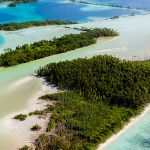
ADAPTATION FOR LOW ISLANDS AND ATOLLS
HERA: Impact of Sea Level Rise and Storms on Coastal Flooding Hazards
The USGS HERA-Impact of Sea Level Rise and Storms on Coastal Flooding Hazards tool provides important scientific information for decisionmakers throughout the Pacific to plan for future coastal flooding events.
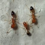
Developing methods to manage Trichomyrmex destructor at Midway Atoll
PI: Jonathan Plissner, Supervisory Biologist, Midway Atoll National Wildlife Refuge and Battle of Midway National Memorial, USFWS
Co-I: Helen Sofaer, Pacific Island Ecosystems Research Center
Funded: FY2024
Co-I: Helen Sofaer, Pacific Island Ecosystems Research Center
Funded: FY2024
Vegetation and climate reconstructions for Palmyra Atoll to develop adaptation strategies for lowland plant communities
PI: David Wahl, Research Scientist, Geology, Minerals, Energy and Geophysics Science Center, USGS
Co-Is: Miriam Jones, Research Geologist, USGS; Kelly Goodale Wildlife Biologist, US Fish and Wildlife Service
Funded: FY2024
Co-Is: Miriam Jones, Research Geologist, USGS; Kelly Goodale Wildlife Biologist, US Fish and Wildlife Service
Funded: FY2024
Pacific Islands Sea Level Rise Project Explorer
Sea-level rise impacts are prevalent throughout the Pacific, as is the research to adapt to those impacts. This new interactive tool compiles information about SLR projects in one place to help avoid duplication of efforts and encourage collaborations for future work.
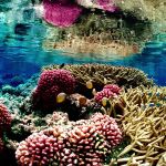
Unlocking reef resilience drivers to inform Pacific coral reef management
PI: Megan Donahue, Marine Researcher, HIMB, UH Mānoa
Graduate Scholar: Jessica Glazner, Dept of Marine Biology, UH Mānoa
Co-I: Chad Wiggins, Palmyra Program Director, The Nature Conservancy
Funded: FY2022
Graduate Scholar: Jessica Glazner, Dept of Marine Biology, UH Mānoa
Co-I: Chad Wiggins, Palmyra Program Director, The Nature Conservancy
Funded: FY2022
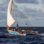
Using oral histories of Marshallese and Yapese voyaging to develop sustainable sea transport
PI: Joseph Genz, Associate Professor of Anthropology, UH Hilo
Graduate Scholars: Jerolynn Myazoe, Dept of Anthropology, UH Hilo; Shania Tamagyongfal, Dept of Anthropology, UH Hilo
Co-I: Alexander Mawyer, Associate Professor, Center for Pacific Island Studies, UH Mānoa
Funded: FY2022
Graduate Scholars: Jerolynn Myazoe, Dept of Anthropology, UH Hilo; Shania Tamagyongfal, Dept of Anthropology, UH Hilo
Co-I: Alexander Mawyer, Associate Professor, Center for Pacific Island Studies, UH Mānoa
Funded: FY2022

Developing a Pacific mangrove monitoring network (PACMAN) in response to sea-level rise
PI: Richard Mackenzie, Research Ecologist, USDA FS Pacific Southwest Research Station
Graduate Scholar: Maybeleen Apwong, TCBES, UH Hilo
Funded: FY2022
Graduate Scholar: Maybeleen Apwong, TCBES, UH Hilo
Funded: FY2022
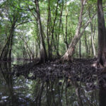
Mangrove vulnerability to sea-level rise factsheet
Mangrove forests and the benefits they provide to Micronesian ecosystems and communities are threatened by accelerating sea-level rise and human activities. Read this factsheet to learn more.
Developing the American Samoa climate and GIS data portal
PI: Christopher Shuler, Assistant Hydrologist, Water Resources Research Center, UH Mānoa
Graduate Scholar: Annie Chien, Earth and Planetary Sciences, UH Mānoa
Funded: FY2021
Graduate Scholar: Annie Chien, Earth and Planetary Sciences, UH Mānoa
Funded: FY2021