Reconstruction of West Pacific climate history
Guam is a living laboratory for climate research in a pivotal part of the planet’s climate system. Guam’s location on the edge of the West Pacific Warm Pool uniquely positions it for informative research on phenomena of global impact (e.g., El Niño; Pacific Decadal Oscillations) as well as phenomena of regional and local importance (e.g., rainfall and drought cycles, sea-level variability, and typhoon origins, behaviors, and characteristics). As our planet currently experiences an exceptionally strong El Niño (so far, almost as severe as the record-setting 1997-1998 El Niño), it is especially important to seize the opportunity to monitor and collect environmental and geochemical data that will enable scientists to evaluate more reliably the characteristics and mechanisms driving past, ongoing, and future western Pacific climatic conditions and events. Moreover, since these mechanisms also control drinking water supplies—both surface and groundwater—for Guam and other islands in the region, water resource managers and policy-makers are already looking to local climate scientists for advice on management of water supplies, including response to storms and droughts.
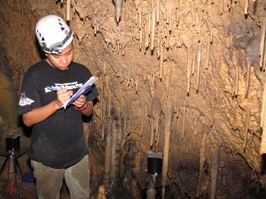
UOG/PI-CSC researchers and their colleagues at the University of Texas-Austin are collecting and analyzing a broad suite of geochemical data: stable isotopes from rainwater collectors, groundwater production wells, and cave drip waters. Water isotopes are powerful natural tracers for monitoring and understanding hydrologic processes on global to local scales. The chemical signatures of isotopes in rainwater, for example, can reveal where a given water mass originated in the Pacific Ocean and what processes it has undergone on its path. One can also use water isotopes to understand crucial hydrogeologic processes, such as groundwater recharge, and to answer critical questions about the fate of storm water, such as whether it contributes to aquifer recharge or merely runs off the lens to the ocean. Isotopic work to date comparing rainwater with subsequent cave drip-waters has already shown that rainfall arriving during Guam’s dry seasons—about one-third of the annual total—does not appear in the percolating water that recharges Guam’s groundwater lens. Well-water analyses are reinforcing this finding. Such understanding is crucial for predicting effects of climate shifts on the drinking water resources of Guam and similar islands. Other related hydrogeologic research leveraged by this project includes an NSF-sponsored collaborative project with the University of South Florida, in which UOG/PI-CSC researchers are locating and collecting carbon dioxide samples from wells in Guam’s aquifer to better understand the processes by which water pathways develop in island karst aquifers.
During the current El Niño, collaborating scientists at UT-Austin analyze water isotopes in rainwater samples collected weekly by scientists at the University of Guam. To our knowledge, this is the only established collection program for rainwater isotopes in the western Pacific Ocean. (With this ongoing work, the UOG/PI-CSC could potentially get established as a GNIP station. There are 17 such stations on the Hawaiian Islands, but few in the southwestern Pacific.) The sampling also includes groundwater samples from drinking water production wells, which is part of a related concurrent project, funded by the Strategic Research and Development Program, led by the USGS’s Pacific Island Water Science Center (PIWSC), in collaboration with UOG, UT-Austin, and the University of Hawai‘i at Mānoa. The rainfall, groundwater, and cave drip-water sample data are thus also contributing to a comprehensive groundwater modeling study led by PIWSC using down-scaled climatic data being computed by workers at UH Manoa. This work will provide a basis for forecasting the effects of changes in climatic cycles and sea level on Guam’s groundwater availability and quality.
Work to date on the reconstruction of past climate on Guam has so far shown that Guam has experienced substantial decadal-scale wet-dry periods, within a general increase in rainfall (of about 30 inches) over at least the past 160 years. Pre-instrumental wet-dry cycles appear to have been of larger magnitude than the subsequent recent cycles. Besides providing local water resource managers and policy-makers with an understanding of long-term trends, documentation of the natural cycles in the western Pacific provides climate scientists with the essential baseline data against which to evaluate hypotheses of anthropogenic effects on climate.
PROJECT DETAILS
FUNDED:
FY2012
PI:
John Jenson
Professor of Environmental Geology, WERI, Univ. of Guam
Co-Is:
Mark Lander
Assistant Professor of Tropical Meteorology, WERI, Univ. of Guam
Alexandra Noronha
WERI, Univ. of Guam
J. Banner
WERI, Univ. of Guam