Monitoring and analysis of climate variability and change in Hawaiʻi

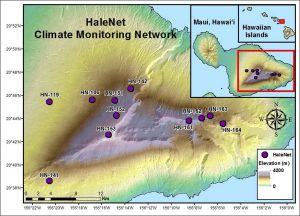
The primary focus of this project was to examine historical climate data obtained at various locations across the State of Hawai‘i in an effort to detect changes in climate at a variety of spatial and temporal scales. One part of this work included an in-depth analysis of data obtained from the HaleNet climate network located on the island of Maui, Hawai‘i. We documented the annual, diurnal and elevational characteristics of 11 climate variables through space and time. Significant findings included decreases in precipitation (-5 to -8% per decade), relative humidity (-3 to -5% per decade), and cloud attenuation of sunlight (-2 to -5% per decade). Concurrently, there were increases in solar radiation (2 to 4% per decade), vapor pressure deficit (9 to 10 % per decade), zero precipitation days (4 to 5% per decade), and potential evapotranspiration (3 to 7% per decade) during the dry-season. These changes were attributed to changes in the frequency of occurrence of the trade wind inversion (TWI).
The TWI is a temperature inversion, a layer in which air temperature increases with height, and is a persistent feature of the atmosphere over large areas of the oceanic tropics. The TWI, which is typically found at about 2200 m (7200 ft) elevation over Hawai‘i, is important to the local climate conditions because it caps the upward growth of clouds and limits where precipitation occurs. In our analysis, atmospheric sounding data obtained from two sites in Hawai‘i, were used to characterize TWI frequency between 1973 and 2013. Results showed that a marked upward shift (20%) occurred in the early 1990’s in the number of days with the TWI present. Increases in TWI occurrence were attributed to a 33% increase in atmospheric subsidence (descending air) during the wet season and a 41% increase during the dry season. The TWI occurrence increases were also linked to changes in high elevation rainfall: 6% lower during the wet season and 31% less during the dry season.
Understanding how climate has changed in Hawai‘i over the past few decades will serve to further stimulate ecological research and help to develop successful management strategies for preserving native Hawaiian ecosystems and properly managing freshwater resources.
PROJECT DETAILS
FUNDED:
FY2012
PI:
Thomas Giambelluca
Professor of Geography, UH Mānoa
Co-PI:
Ryan Longman
Department of Geography, UH Mānoa