Groundwater percolation in northern Guam: Insights from Jinapsan Cave
Background
The Northern Guam Lens Aquifer (NGLA), a freshwater lens within the limestone bedrock that covers the northern half of the island, supplies 90% of Guam’s fresh water. Water that falls on the land surface and escapes absorption by plants infiltrates the limestone bedrock and eventually ends up in the freshwater lens, where it is ultimately pumped up into wells to supply water to the island’s population. Since the NGLA is Guam’s sole source aquifer, understanding the processes associated with movement of water through the aquifer system is vital to protecting and managing this precious resource.
A particularly region of importance within the aquifer is called the vadose zone, which is an unsaturated limestone layer between the land surface and water table. The pores of this limestone are partially filled with water as it infiltrates down through the rock, either slowly by pore-to-pore percolation, or rapidly through pathways like natural fractures, shafts, and sinkholes. Understanding the movement of water through the vadose zone gives valuable insight into important aquifer details, such as the difference in aquifer recharge rates during wet and dry seasons, or the transport of contaminants through the limestone, and thus the quality of the water ultimately pumped out.
Project Summary
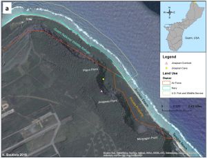
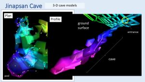
The purpose of this project is to understand the water flow through the 200-500 ft thick vadose zone of the NGLA by studying Jinapsan Cave, a natural cave system that serves as an underground observatory of groundwater percolation through the NGLA. Jinapsan Cave is located on the Guam National Wildlife Refuge at the northern tip of the island, within the margins of Anderson Air Force Base (Fig 1). As part of the project, a detailed three-dimensional map of the cave was made from an interior 5-m grid survey (Fig. 2), to enhance visualization of the relationship between data collection points and the entire cave system.
To understand better the percolation of water through the cave, data collected over the last six years were examined. Monthly observations and drip-water samples from seven cave stations, spanning the whole length of the cave system, were converted to time-series data on drip rates. Correlations were then made between drip rates and storms, seasonal changes in rainfall, and changes in bedrock geology.
Drip rates across the cave system vary by orders of magnitude between different locations and different seasons. For example, during the wet season, rates at different cave stations range from 2000 drips/hr to less than 5 drips/hr. But for many stations, there are also visible repeating patterns between the wet and dry season, with decreasing drip rates followed by increasing drip rates after storm events, creating a sawtooth, fluctuating pattern.
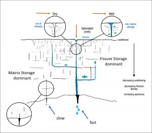
From detailed examination of the correlations found, a general conceptual model was developed of the vadose zone over the limestone aquifer (Fig. 3). Generally, flow is controlled by the dominant storage porosities, matrix storage versus fissure storage. Matrix storage dominates where the rock is less weathered and more coherent, leading to slow percolation and low drip rates. Fissure storage dominates where there is greater weathering to cause greater fracture density, leading to fast percolation and high drip rates.
Firstname Lastname (if any)
title/affiliation
PROJECT DETAILS
FUNDED:
FY2015
PI:
John Jenson
Professor of Environmental Geology, WERI, University of Guam
Co-PI:
Kaylyn Bautista
WERI, University of Guam