Very fine resolution dynamical downscaling of past and future climates for assessment of climate change impacts on the islands of Oʻahu and Kauaʻi

The Hawaiian Islands are home to many people and host a rich diversity of unique plant and animal life, but they are especially vulnerable to the effects of climate change because of their small size, geographical remoteness, and exposure to threats such as sea-level rise and increased storm surge. Developing predictions of future conditions is often the first step in helping decision makers and communities plan for change. However, to date, available global climate models have been too coarse in resolution to be useful for planning in the context of small, isolated islands.
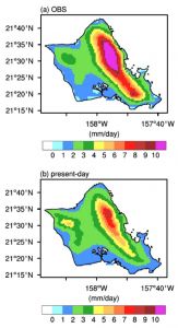
This project produced very high resolution climate projections for the Hawaiian islands of O‘ahu and Kaua‘i, providing information on key variables of interest to decision makers such as rainfall, air temperature, and tropical cyclone patterns. Modeling results suggest that in addition to becoming significantly warmer, the islands are expected to experience an increasing number of heavy rainfall events and tropical cyclones through the current century. These data will aid local decision makers as they plan for impacts to human health, infrastructure, and ecosystems and seek to reduce risk through effective adaptation.
PROJECT DETAILS
FUNDED:
FY2013
PI:
Professor of Meteorology/IPRC, UH Mānoa
Co-I:
Kevin Hamilton
Professor of Atmospheric Sciences/IPRC, UH Mānoa