Estimating coastal erosion rates on Hawai‘i Island to inform setbacks
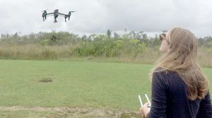
Despite its vast coastline and unique coastal ecosystems and resources, Hawai‘i Island has never had a comprehensive shoreline assessment of coastal vulnerabilities or any systematic monitoring of long-term shoreline change rates. Consequently, Hawai‘i Island is in a weak position for adapting to the potential impacts of sea-level rise (SLR), building community resilience, and conserving key coastal resources and environments. This project seeks to quantify historic and current coastal erosion rates for selected priority areas on Hawai‘i Island. Existing shoreline records, including historic aerial photographs and LiDAR coastal surveys, will be combined with new coastal imagery and three-dimensional data sets collected from unmanned aerial vehicles (UAV) and other survey platforms to determine past and current shoreline change rates. These data will then be merged with SLR projections and other geospatial layers to estimate future impacts. The priority areas for this study represent a variety of coastal environments at different stages of development, including sea cliffs (Honoli‘i), low-lying and subsiding coastal lava fields (Kapoho), and calcareous beaches (Hapuna). These data will provide a visualization tool for communities and county workers to understand local impacts of SLR and consider necessary adaptations.

Project Collaborators
Primary Contact and Masters Graduate Student:
- Rose Hart (rosehart@hawaii.edu)
Faculty Advisor:
- Ryan Perroy, Assistant Professor of Geography and Environmental Science, University of Hawaiʻi at Hilo
Committee Members
- Steven Colbert, Assistant Professor of Marine Science, University of Hawaiʻi at Hilo
- Charles H. Fletcher III, Associate Dean and Professor, School of Ocean and Earth Science Technology, University of Hawaiʻi at Mānoa
- Bethany Morrison, Planner, County of Hawaiʻi
US Climate Resilience Toolkit Case Study
PI-CASC News: US Climate Resilience Toolkit Receives Attention
PI-CASC News: CNN Reports on UH Hilo Field Team Tracking Lava Flow from the Night Sky
PI-CASC News: Excellence Award from the Institute of Mathematics
UH Hilo Stories: “Climate change research at UH Hilo: Monitoring the coasts for signs of erosion and planning ahead”
PROJECT DETAILS
FUNDED:
FY2016
PI:
Ryan L. Perroy
Associate Professor of Geography and Environmental Science
UH Hilo
Co-PI:
Rose Hart
Tropical Conservation Biology & Environmental Science
UH Hilo
Steven Colbert
Assistant Professor of Marine Science
UH Hilo
Charles Fletcher
Professor of Geology & Geophysics
UH Mānoa
Bethany Morrison
Planner
County of Hawaiʻi