
Typhoon Mawar batters Guam; PI-CASC Guam lead conducts aerial damage assessment
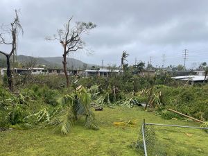
From noon of May 24 to the early morning of May 25, Category 4 Typhoon Mawar ravaged Guam with powerful winds of up to 145 mph. The island endured some 15 hours of destructive winds, torrential rain and lightning, which left behind battered buildings, fallen trees, and substantial damages to infrastructure and utilities.
Mawar was the strongest typhoon that Guam had endured in a little over two decades. And while residents had time to prepare and take shelter, the resulting destruction put a lingering halt to daily activities. More than 90% of the island had lost power, water, and phone service following the storm, and people frantically searched for limited supplies to repair and restore their properties. Debris cleanup continues to this day, and about a third of island residents are still waiting for their power or water, or both, to come back on.
“It has been decades since Guam had experienced a typhoon of this caliber. There were substantial losses to our infrastructure and natural resources, which are still in recovery mode three weeks later,” said Romina King, University of Guam associate professor of geography at the Western Pacific Tropical Research Center and UOG lead of PI-CASC.
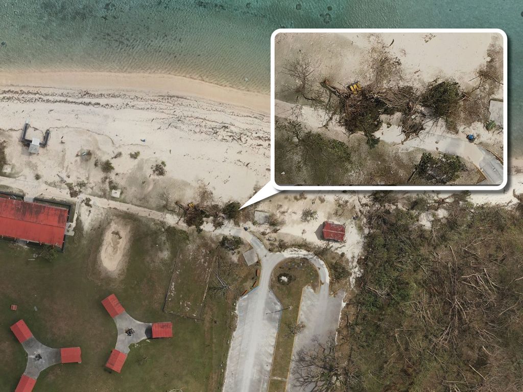
Shortly after Mawar’s passing, King formed a small team of drone pilots and partnered with the National Weather Service Guam to conduct post-storm impact mapping along the coastlines of the villages of Tumon, Hagåtña, Agat, and Mangilao. This mapping effort sought to provide visual proof of storm-related coastal inundation, beach erosion, and other related damages.
“Teaming up with NWS, we flew drones over critically affected areas to collect aerial imagery of coastlines, infrastructure, and vegetation that were ravaged by the typhoon. This data will give our island leaders a more in-depth look at the extent of damage from Typhoon Mawar, and they can determine which problems to prioritize once the island is in a more stable place,” King said.
Her team’s work will be a valuable tool for local decision makers in prioritizing areas for humanitarian support, as well as planning for future challenges. Additionally, this resource will help scientists define the horizontal extent of storm-driven coastal flooding, providing invaluable data that will help USGS sea level rise and storm inundation modelers refine their work.
Typhoon assessment
Since May 20, meteorologists at NWS Guam had been monitoring the system which eventually became Typhoon Mawar, a Malaysian word meaning “rose.” Starting from southwest of Chuuk, Mawar slowly made its way towards the Marianas, intensifying in its path. Mawar had strengthened to a Category 5 supertyphoon with wind speeds upwards of 155 mph, before weakening to an estimated 145 mph as it made landfall on Guam.
“Impacts ranged from moderate in the south to devastating in the north (of Guam), closest to the eye of Mawar,” according to NWS’s Post Tropical Cyclone Report. “Wind-related impacts decreased farther to the north across the Commonwealth of the Northern Mariana Islands. While little coastal inundation was reported across the CNMI, extensive erosion occurred along all shores of Guam with sea waters surging well above normal water levels due to the combination of storm surge, ocean surface wind stress, and wave action.”
The Marianas fortunately was spared from the full force of the typhoon, which later intensified to a supertyphoon again with sustained winds of up to 185 mph.
Assessments of the total dollar damage loss to the island is ongoing, but an early estimate reported by Guam’s commercial sector is $111,791, 358, inclusive of damages to buildings, equipment, and merchandise. This amount was determined through surveying 434 businesses, which was coordinated by the Guam Bureau of Statistics and Plans and partnering agencies.
How to help
Three weeks after the storm, some Guam residents are still in need of assistance. The Federal Emergency Management Agency and the U.S. Army Corps of Engineers are on island assisting those in need, but some organizations are also accepting donations that will go towards humanitarian aid.
- American Red Cross – donate to the Typhoon Mawar Relief Fund by visiting redcross.org/donate (select Typhoon Mawar from the dropdown menu)
- Micronesia Climate Change Alliance – donate to the Mutual Aid Fund. Visit MCCA’s Instagram page at @micronesiaclimateallliance for more information.
- Nihi Indigenous Media – donate supplies to help restore northern Guam communities. Visit Nihi’s Instagram page at @nihikids for more information.
- Guahan Sustainable Culture – donate funds to go towards financial support for farmers, food donations and community garden repairs. Email support@gusustainable.org for more information.
More information on Typhoon Mawar and local weather
The video to the right is an interview with NWS meteorologists and siblings Brandon and Landon Aydlett, conducted by Farron Taijeron. Taijeron is the host of The Guam Guy Podcast and is a PI-CASC Climate Adaptation for Resource Management fellow.