“The Mysteries of Kīlauea and the Hawaiian Islands”: PI-CASC’s interactive geonarrative merges science and culture to teach Hawaiian volcanism
August 12, 2024

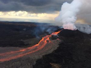
The U.S. Geological Survey’s (USGS) Pacific Islands Climate Adaptation Science Center (PI-CASC) launched an interactive Kīlauea geonarrative in July. This visual educational tool incorporates four Next Generation Science Standards (NGSS) aligned lessons that weave Hawaiian moʻolelo (story) and art. The lessons cover volcanic hazards, groundwater, and data analysis while highlighting the volcano’s formative stories.
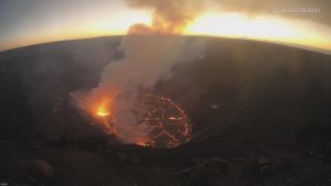
In 2018, the Kīlauea eruption caused one of the largest collapses of the summit caldera in 200 years. This eruption led to Halemaʻumaʻu, the volcanic crater at the summit of Kīlauea, doubling in size. Scientists observed a small pond at the crater’s center about one year later.

Those same scientists began monitoring the water in the crater’s core. Over 17 months, they observed the water level steadily increasing until the pond became a lake. On December 20, 2020, a vent opened in the crater walls, sending lava gushing into the crater, which subsequently burned off all the water in the lake in about 1.5 hours. This unique phenomenon created an interesting data set that became the foundation of this resource.
“It started with this interesting dataset from USGS,” said Emily Sesno, PI-CASC outreach biologist and education lead who led the development of the lesson plan. “A colleague came to us with a really cool data set showing the increase of water in a volcanic crater, of all places. You don’t usually think that water and volcanos go together. And then, it boiled off so quickly -17 months of steady water increasing, gone in an hour and a half. It got me thinking about ways to explore unique phenomena in the Pacific Islands.”
Sesno developed the educational resource with contributions and reviews from Annie Scott (previously with the USGS Youth and Education in Science program, now a Staff Scientist with the USGS Office of Tribal Relations), Joel Truesdell (Albert Einstein Distinguished Fellow program fellow in 2021-22), Elizabeth Westby (USGS Cascades Volcano Observatory), and Katie Mulliken (USGS Hawaiian Volcano Observatory).
From that data set and inquiry came a comprehensive geonarrative. The geonarrative contains four lessons geared towards 4th and 5th-grade students, but can also be adapted to higher grades. The 20-30 minute lessons feature hands-on exploration and data analysis, skills that are especially valuable for students considering careers in science.
Teachers using the geonarrative in their classrooms can expect their students to gain:
- An understanding of how hotspot volcanism formed the Hawaiian islands and why Hawaiʻi maintains active volcanoes
- Insights into earth science through art and traditional Hawaiian knowledge
- The ability to explain phase changes and interactions between the hydrosphere (Earth’s total water) and geosphere (Earth’s rocky component)
- Skills in developing models of hotspots and groundwater
- Competence in reading and interpreting USGS data
Hotspots: The Formation of the Hawaiian Islands
The Kīlauea geonarrative introduces hot spot volcanism, groundwater, and the appearance of a mysterious lake while weaving Hawaiian moʻolelo and art.
Volcanic hotspots are how the Hawaiian Islands were formed. Many volcanoes form at tectonic plate edges, but some erupt from a stationary point beneath a plate, creating “hotspot” volcanoes. These unusual volcanoes can remain active for millions of years in the same location.
Scientists still don’t fully understand the origin and mechanics of hotspots. However, they’ve gathered information from studying the Hawaiian Islands and underwater ridges on the Pacific Plate. This evidence shows the plate has been moving west-northwest for about 43 million years. The older, inactive volcanoes form a chain extending northwest from the current hotspot, aligning with the plate’s direction of movement. While the Hawaiian Islands are a prime example of hotspot volcanism, they’re not unique. Several other island chains worldwide, including the Marquesas, Society, Pitcairn, Samoan, and Galapagos archipelagos, also formed through similar hotspot processes.
Groundwater and The Mysterious Crater Lake
Scientists observing the water in Halemaʻumaʻu crater faced a puzzling question: What was its source? To find the answer, they looked at Keller Well, a deep well (borehole) drilled in 1973 on the southwest rim of Kilauea’s caldera. These observations helped scientists understand the behavior and characteristics of water in the area.
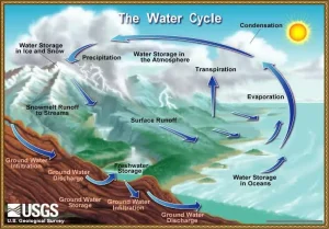
Before the 2018 collapse, the lava lake at the Halemaʻumaʻu crater was about 1 kilometer (0.62 miles) north of the well. After the collapse, scientists found that the new crater rim had moved 250 meters (820 feet) closer to the well. To put this in perspective, the distance changed from about 82 school buses lined up end-to-end to just 21 buses. This shift represented a significant change in the crater’s size and position. With this new information, scientists concluded that the lake’s water came from groundwater, not rainwater which would have fluctuated with rainfall. Understanding the water cycle helps students to grasp the larger impacts of climate on our water supply.
“The {Kīlauea} lesson focuses on this unique phenomenon, but is also a really interesting way to tie together relationships between environmental systems – the hydrosphere, biosphere, geosphere, and atmosphere. And, we can explore more about climate change through investigations of the water cycle,” said Sesno. “It’s important to understand where water is, especially on an island where water resources are so valuable and finite.”
This dramatic interaction between lava and groundwater provides students with a vivid, place-based example of the water cycle in action, illustrating how Earth’s systems can interconnect in unexpected ways.
Hawaiian Moʻolelo: Pele and Namakaokahaʻi’s Journey
An important aspect of the Kīlauea Geonarrative’s development was weaving the moʻolelo and knowledge of Native Hawaiians. In this case, studying the journey of Pele, the Hawaiian goddess of fire and volcanoes, and her younger sister Nāmakaokahaʻi, the goddess of the ocean, mirrors the geological formation of the Hawaiian Islands.
The moʻolelo of Pele continues to be a source of knowledge that anchors Hawaiian people to the ʻāina, their genealogy, and history. It also showcases the keen insights Hawaiian people gained through observation long before the influence of Western science.
Katie Mulliken, geologist at the USGS Hawaiian Volcano Observatory (HVO) commented on the impact of Hawaiian moʻolelo in science:
“Native Hawaiian oral traditions can inform our understanding of volcanic activity and how to answer real-life questions about changes at volcanoes in Hawaii,” said Mulliken. “{These} traditions provided clues that this type of activity had been observed in the past, and, in combination with data collected by HVO as the water lake was rising, helped us understand the water’s origin.”
The PI-CASC Education Hub will continue to grow with new lessons and resources. Visit the Education Hub website to stay \informed and leave your information on our Contact Us page to receive email updates and for opportunities to collaborate.
Sources:
What is a hotspot and how do you know it’s there? | U.S. Geological Survey (usgs.gov)
Evolution of Hawaiian Volcanoes | U.S. Geological Survey (usgs.gov)
Hydrosphere (nationalgeographic.org)
Earth’s Systems (nationalgeographic.org)
Volcano Watch — Hotspots | U.S. Geological Survey (usgs.gov)
Volcano Hazards Program Glossary | U.S. Geological Survey (usgs.gov)
Groundwater: What is Groundwater? | U.S. Geological Survey (usgs.gov)


