RESEARCH PROJECTS
PI-CASC supports research that generates actionable climate science within several key focus areas defined by regional stakeholder needs.

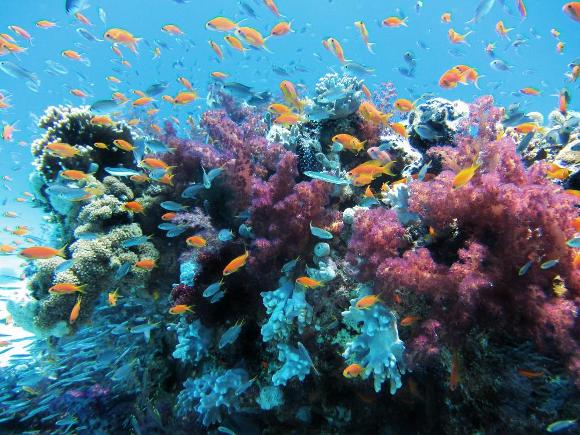
Using cutting-edge technology to assess coral reef bleaching and recovery in Guam and CNMI
PI: Romina King, Associate Professor of Geography, University of Guam
Co-PI: Ved ChirayathResearch Scientist, NASA Ames Research Center
Funded: FY2020
Co-PI: Ved ChirayathResearch Scientist, NASA Ames Research Center
Funded: FY2020
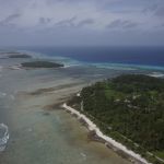
How ridge-to-reef governance in Palau can enhance coastal food security
PI: Kirsten Oleson, Associate Professor of Ecological Economics, UH Mānoa
Co-PI: Michelle Harangody, Department of Geography and Environment, UH Mānoa
Funded: FY2020
Co-PI: Michelle Harangody, Department of Geography and Environment, UH Mānoa
Funded: FY2020
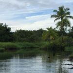
A shoreline inventory for Hawai‘i island to increase resilience
PI: Ryan Perroy, Associate Professor of Geography and Environmental Science, UH Hilo
Co-PI: Aloha Kapono, Tropical Conservation Biology and Environmental Science Program, UH Hilo
Funded: FY2020
Co-PI: Aloha Kapono, Tropical Conservation Biology and Environmental Science Program, UH Hilo
Funded: FY2020
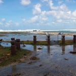
Sea-level rise viewer for American Samoa
PI: Phil Thompson, Associate Director of UH Sea Level center, UH Mānoa
Co-PI: Carla Baizeau, Department of Oceanography, UH Mānoa
Co-Is: Kelley Anderson Tagarino, Extension Specialist, American Samoa Community College; Justin E. Stopa, University of Hawaiʻi at Mānoa; Curt Storlazzi, Research Geologist, USGS Pacific Coastal and Marine Science Center
Funded: FY2020
Co-PI: Carla Baizeau, Department of Oceanography, UH Mānoa
Co-Is: Kelley Anderson Tagarino, Extension Specialist, American Samoa Community College; Justin E. Stopa, University of Hawaiʻi at Mānoa; Curt Storlazzi, Research Geologist, USGS Pacific Coastal and Marine Science Center
Funded: FY2020
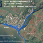
Sea-level rise impacts on coral reef and mangrove interactions and resulting coastal flooding hazards
PI: Curt Storlazzi, Research Geologist, USGS Pacific Coastal and Marine Science Center
Co-I: Karen Thorne, Research Ecologist, USGS Western Ecological Research Center
Funded: FY2020
Co-I: Karen Thorne, Research Ecologist, USGS Western Ecological Research Center
Funded: FY2020
The impact of climate change and sea-level rise on the future flooding of coastal parks and refuges in Hawaiʻi and the US Affiliated Pacific Islands
PI: Curt Storlazzi , Research Geologist, USGS Pacific Coastal and Marine Science Center
Funded: FY2019
Funded: FY2019

Visualizing sea-level rise at Pu‘uhonua O Hōnaunau National Historic Park
PI: Philip Thompson, Assoc. Director of UH Sea Level center, UH Mānoa
Co-PI: Nemanja Komar , Scientific Programmer, UH Sea Level center, UH Mānoa; Darren Lerner, Director, Hawaiʻi Sea Grant College Program
Funded: FY2019
Co-PI: Nemanja Komar , Scientific Programmer, UH Sea Level center, UH Mānoa; Darren Lerner, Director, Hawaiʻi Sea Grant College Program
Funded: FY2019
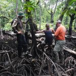
The future resiliency of mangrove forests to sea-level rise in the Western Pacific
PI: Karen Thorne, Research Ecologist, USGS Western Ecological Research Center
Co-PI: Richard MacKenzie, Research Ecologist, US Forest Service
Funded: FY2019
Co-PI: Richard MacKenzie, Research Ecologist, US Forest Service
Funded: FY2019

A next generation beach observing system for Hawai‘i
PI: Charles Fletcher, Professor of Earth Sciences, UH Mānoa
Co-PI: Anna Mikkelson, Department of Earth Sciences, UH Mānoa
Funded: FY2018
Co-PI: Anna Mikkelson, Department of Earth Sciences, UH Mānoa
Funded: FY2018
Integrating climate science with local knowledge through community vulnerability assessment on Kaua‘i
PI: Daniele Spirandelli, Asst. Professor of Urban Design and Planning, UH Mānoa
Co-PI: Alisha Summers, Department of Urban and Regional Planning, UH Mānoa
Funded: FY2018
Co-PI: Alisha Summers, Department of Urban and Regional Planning, UH Mānoa
Funded: FY2018
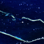
Characterizing inundation risk for Majuro Atoll
PI: Dean Gesch, Research Scientist, USGS Earth Resources Observation and Science (EROS) Center
Co-PI: Jeff Danielson , Physical Geographer, USGS Earth Resources Observation and Science (EROS) Center
Funded: FY2017
Co-PI: Jeff Danielson , Physical Geographer, USGS Earth Resources Observation and Science (EROS) Center
Funded: FY2017
Impacts of climate change in loko i‘a (traditional Hawaiian fishponds) management I
PI: Steven Colbert, Assistant Professor of Marine Science, UH Hilo
Co-PI: Cherie Kauahi, Tropical Conservation Biology & Environmental Science, UH Hilo
Collaborator: Noelani Punawai, Assistant Professor, Kamakakakūokalani Center for Hawaiian Studies, UH Hilo
Funded: FY2016
Co-PI: Cherie Kauahi, Tropical Conservation Biology & Environmental Science, UH Hilo
Collaborator: Noelani Punawai, Assistant Professor, Kamakakakūokalani Center for Hawaiian Studies, UH Hilo
Funded: FY2016

Impacts of climate change in loko i‘a (traditional Hawaiian fishponds) management II
PI: Steven Colbert, Associate Professor of Marine Science, UH Hilo
Co-PI: Kamala Anthony, Tropical Conservation Biology & Environmental Science, UH Hilo
Collaborator: Noelani Punawai, Assistant Professor, Kamakakakūokalani Center for Hawaiian Studies, UH Hilo
Funded: FY2016
Co-PI: Kamala Anthony, Tropical Conservation Biology & Environmental Science, UH Hilo
Collaborator: Noelani Punawai, Assistant Professor, Kamakakakūokalani Center for Hawaiian Studies, UH Hilo
Funded: FY2016
Collecting elevation data to understand climate change effects in the Marshall Islands
PI: Jeffrey Danielson , Physical Geographer, USGS Earth Resources Observation and Science (EROS)
Co-Is: Monica Palaseanu-Lovejoy, Research Geographer, USGS Eastern Geographic Science Center; Cindy Thatcher, Research Biologist, Cooperative Data Acquisition, NGPO; Dean Gesch, Research Scientist, USGS Earth Resources Observation and Science (EROS) Center; Matthew Barbee, Biologist, UH Mānoa; Romina King, Asst. Professor of Geography, University of Guam; Maria Kottermair, GIS specialist, University of Guam
Funded: FY2016